Ancient historians had left us a wealth of material about the Scythians and Scythia, which, however, can not always be relied upon. Thou, this is not the fault of the historians but the consequence of the nascent state of historical scholarship and the result of the geographical imaginations of the historians at the absence of a reliable cartographic base. That only is the assertion of Herodotus that Scythia is an almost regular quadrilateral, which is quite impossible to place on the modern map.
When he submits the names of gods and men, geographical names or names of tribes and different realities of those times, it's a concrete material, which should only be used skilfully. Unfortunately, too often, many scientists 'skilfully' used it in their own interest. Now, when we know the ethnic origin of the Scythians and their neighbors, this material may not only confirm the heuristic reasoning, but also enrich our understanding of that distant era.
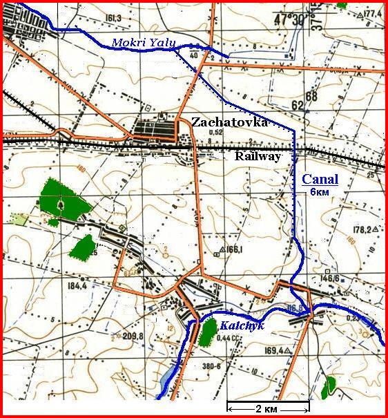
We have already explained the names of Scythian gods, but Scythian place names may also have an explanation by means of the Chuvash language. For example, the name of the area Exampaios between the river Borysthenes and the river Hypanis may correspond to Chuv uksăm "wild garlic" and puy "to grow rich". The river Panticapes can be explained as "mouldy" (Chuv păntăh "mould" and kap "shape"). Some researchers identify Pantukapes with the river Molochna (Milky), the tributary of the lower Dnepr. The ancient and modern-day names of the river may have an identical explanation if the water in the river had (has till now?) whitish painting which gives the reason to compare its color with milk or with mould. The nameof the river Kypakyris can be translated as "chaff" or something similar (Chuv. kipek "peels" and irěš "bran"). The name of the river Gerros can be connected with Chuv. kěre "a ford". By words Herodotus, the Gerros follows from the Dnepr to the sea and runs in the Kypakyris near it. Obviously, ancient inhabitants of the Azov Sea coast named by the Gerros the waterway has been formed by low currents of the river Samara, the rivers Vovcha, the Mokri Yaly, and the Kalchyk which runs in the river Kalmius near to its mouth. The Kalchik and the Mokri Yaly come so nearer to each other in one place that, else during rather near historical times, the Zaporozh cossacks drew their boats from the one river in the another by land. This fact was described by G. de Bauplan (BAUPLAN de GUILLAME le VASSEUR, 1998)though he has wrongly named the Kalchyk as the river Miuss. Closely considering a modern topographical map, one can see that the isthmus, which separates the Mokri Yaly from the small tributary of the Kalchyk, has the distance not more than six kilometers, and both rivers could be connected with a channel so that to form a continuous way from the Sea of Azov up to the Dnepr (See Map 9). The map shows that a narrow valley leaves the river Mokri Yaly, it could be a small river in ancient times. Using this valley, it was possible to facilitate the work of hydraulic engineering, though increasing the length of the channel at the same time. Initially, this could just be a quagmire, which could be waded, and this explains the name of this whole waterway "Gerros" as a ford. Herodotus wrote that slaves dug a broad trench extending from the Tauric mountains to the Maiotian lake (the Sea of Azov) , at the point where this is broadest. If the Tauric Mountains assume the Donetsk ridge, the trench would thus channel. Traces of this canal, in principle, can be found fairly easily, but now the isthmus railroad passes (see map).
Incidentally, the name of the river Mokri Yaly can mean "a waterway," because the Turkic languages have the word jol/joly "a way" and Ukr.mokri means “wet”. If you look Turkic correspondence to the first part of the name, taking words with meaning "water", "wet", we suddenly come to the river Kayala known for the Ipatiev Chronicle. M. Vasmer and K. Menges (MENGES K.H., 1979: 100) argue that the correct form of the name is not Kayala but Kayaly. M Vasmer said about the explanation of the name of the river as qaj + jaly "a river with slippery banks", proposed by M. Sokol, but disputed it, because qaj is "just a verbal basis", while the second part of the word was borrowed by the "Southwest" Turkic languages from modern Greek γιαλοσ "a sea-shore, beach" (ibid., 102). This is not so, because the Gagauz and Turkish languages have a word qaj-ğy, where ğy - adjective suffix from the nominal basis (in other Turkic languages "slippery" – tajğy). If we take Turk. joly, turned into jaly in one of the "a-speakin" dialects, we get an explanation of the name of the river Kayala as "a slippery way". Semantically, it is close to the name of "wet way" if our assumption about the existence of wetlands between the Mokri Yaly Kalchik is true. Especially if there had been drag-way on the wet areas.
Left: Map 9. The river Gerros – the Waterway from the Dnepr to Azov Sea.
Thus Gerros (Kayaly) was a water route from the Dnieper to the Sea of Azov, and then the Kypakyris can be identified with the river Kalmius. In this case it turns out that no the river Mius was mentioned by Herodotus, and Kypakyris in accordance with his order of enumeration of the Scythian rivers would have to be west of the Gerros, not east, as follows from our arguments. Many scholars tried to put in order Herodotus’ muddled data, but so far no one was able. Obviously, we should recognize that they are true only partly. The Greek historian mentioned as the last the Tanais which, obviously, is to be understood, as many have done before, the lower reaches of the Don and the Siversky Donets. Probably, Herodotus and his informants did not know anything about the true Don, because if they would know it then they were certainly aware of the Volga, as they converge in this area very closely and this interesting fact could not be silent on. However Herodotus said nothing about any powerful waterway which could correspond to the Volga.
It is very difficult to establish ethnicity, and places of settlement of individual Scythian tribal groups on Herodotus' data. We have already mentioned that a sufficiently large number of Scythian names can be explained by means of the Old English. This could be considered an accident if it would not turned out that even more indecipherable Sarmatian and Alanian names of Abaev's Onomastikon have Old English interpretation. For a more detailed consideration of this matter, a list of names belonging to the Scythian-Sarmatian time and having a good interpretation by means of the Old English had been compiled on the basis of assembly of V. Petrov, V. Abaev, J. Harmatta, V. Latyshev, N. Knipovich and others. There are among these names many belonging to Alans, so the list became the code name "Alano-Anglo-Saxon Onomasticon".
The number of names which can be decrypted using the Old English language is very large, although no doubt that some interpretation may be erroneous. This fact may be explained by the fact that the ancient Anglo-Saxons which moved to the left bank of the Dnieper and settled in the basins of the Desna and Seym remained here until the Scythian time and later moved to the Black Sea. At the same time, the southern and south-eastern boundary of the Urheimat of the Anglo-Saxons was held at the river Teteriv, which separated the ancient Anglo-Saxon settlements from the Thracians. Name of the city of Zhitomir, we explained as "a border protection" (OE scyttan "to shut, close", mer "a border") but OE scytta had also the sense "a shooter" and by sounding is close to the Greek name of the Scythians Σκυθαι. The Scythians were considered to be the best bow shooter and the ancient Greek ethnonym "a Scythian" was considered as the synonymous to the shooter. In this regard, we can assume that the Greek word for the Scythians may occur from the Old English word meaning "a shooter". In this case, some group of Anglo-Saxons was to hold near Zhytomir for as long as the Scythians-Bulgar pushed the Thracians out.
The neighborhood of the Anglo-Saxons and the Scythians may be confirmed by interpretation of some Scythian realities by means of Old English. For example, the name of the Scythian short sword akinakes (ακινακεσ), which is probably corresponded to Iranian kynk "a sword", is well explained “a killing ax” OE æces "an ax" and nǽcan "to kill". Another Scythian weapon, the battle ax sagaris (σαγαρισ) could also get the name from the Anglo-Saxons – OE sacu "a strife, war" and the earh "an arrow". The name of the Scythian clothing σακυνδακη was explained by V. Abayev as "the clothes from deer fur" (Os sag "a deer" and the tag/dag "a thread, woven fabric"), which is not entirely correct, as in this case the question is not the wool, but the skin. Too much deer would be need to collect their wool but the Scythians were not engaged in deer herding. Perhaps the second part of the word is OE đescan "to cover", akin to Lat. tŏga "a toga", tĕgĕre "to cover." The first part of a word can be translated as "Sakian", but also as "battle, war" (cf. OE sacu "a strife, war"). The name of the large boneless fish αντακαιοι has no convincing explanation. In accordance with the peculiarities of the fish, the prefix could mean "without, no”. Such words are present in Germanic languages (eg O.N.Gmc an/on). Then the root would have sense "a bone". Maybe Dt tak "a branch" and Ger Zacke "a spike" of unknown etymology can suit as their meaning is close to the sense "a bone". Then the third part of the word may be akin to Ger Hai “a shark," whose origin is hidden somewhere in North Germanic languages, but the proto-form of the word was supposed to be *kai. It is known that sharks are cartilaginous fishes, ie, boneless.
The possibility to decipher the names of the Scythian realities, as well as the names of some tribes by means of Old English seems strange if the Anglo-Saxons, not being Scythians, left a large tace in the Scythian vocabulary. It is appropriate to recall Herodotus’ words:
How many the Scythians are I was not able to ascertain precisely, but I heard various reports of the number: for reports say both that they are very many in number and also that they are few, at least as regards the true Scythians (HERODOTUS., 1993: IV,81.)
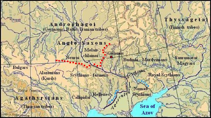
Thus, Herodotus after his informants could sometimes call the Scythians also other peoples of the Northern Pontic country. The Anglo-Saxons can be connected with the Neuroi of Herodotus, if we assume that he listed the tribes in order from west to east.
Right: Scythia at Herodotus' time.
Red dots mark the defensive line of Anglo-Saxons, going from Zhitomir to the Dnieper and continued further along the Sula River. This boundary was composed of earthworks and hillforts that are particularly clearly visible along the right bank of the Sula.
Just the Neuroi stood as the second in the listing after the Thracians-Agathyrsians. Herodotus indicated that they left their homeland and settled among the Budinoi . OE neowe, niowe means "new". The nominalization of the word could give neower "a newcomer." The Anglo-Saxons could not call themselves newcomers, it is logically assume that such name them could give the local settlers, ie, the Anglo-Saxons, who came here formerly at the time of Trzciniec culture. This first wave of the Anglo-Saxons, judging by the place names and sites on the territory of East-Trzciniec on the Left Bank Ukraine, occupied basins of the Seym, the Low Desna, while the basins of the Sulla and Psel were settled by the Mordvins. Herodotus places Melanchlainoi to north of the Royal Scythians and explains their name as "dressed in black" (Gr. μελασ "black").In fact, it is Old English name, as ancient Angles had a proper name Mealling, originated from OE a-meallian "to get furious" (see HOLTHAUSEN F. 1974: 216), which together with OE hleonian "to protect" was used by Scythians for calling Anglo-Saxons.
The Budinoi are connected by many scientists with the ancestors of the Mordvins, and this assumption has some justification, but as it turned out, deciphering of the names of Budinoi by means of Old English confirms our assumption. Βουδινοι, perhaps even "Wudinoi", according to Herodotus, were the inhabitants of the forest country. In this case, OE widu, wudu "wood, forest", Eng wooden by the meaning and phonetically are suitable perfect. The word wuden was not found in the Old English but it could exist and mean "forest" on the laws of English grammar.
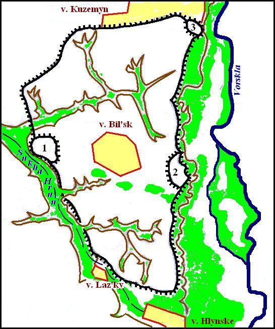
Herodotus located the city of Gelon in Budinoi country. Scientists did not come to consensus about its real place. B.Shramko long argued that the sity has to be connected with Bilsk hillfort on the Vorskla River (SHRAMKO B.P. 1987), but V. Il'inski refuted this hypothesis. (IL'INSKAYA V.A. 1977: 91-92). Certainly Shramko rights. Bilsk hillfort has impressive dimensions – the total length of ramparts is 33 833 m, their height is now 6 m and width – up to 9 m (SHRAMKO B.P. 1987: 25). Mordvinian epos about building a great city (MASKAYEV A.I. 1965: 298) confirms Shramko's idea. In addition, Mordvinian place names in the basin of the left tributaries of the Dnieper say to its favor (see. Section "Finno-Ugric toponymy in Central Russia and Ukraine"). Judging by the toponymy, Mordvinian tribes had to hold the territory of the left bank of the Sula River and basin of the Psel and Vorskla Rivers, ie north-western part of the area of Bondarykha culture. This culture, which existed in the interval 1200 – 800 years BC, is associated with its predecessor Maryanivka sites which occur on the Desna, Seym, Sula, Vorskla, Sev. Donets and Oskol Rivers (BEREZANSKAYA S.S. 1982: 41). Bondarykha culture goes beyond Maryanivka in the area between the Seym and Sula Rivers. It was just here Lebediv culture was spread later created by Anglo-Saxons. Clicking on the left bank of the Dnieper Saxons pushed Mordovians in Sulu, and may also have assimilated its remnants, which is reflected in the otherwise unexplained lexical correspondences between the English language and Mordovia. Crossing Dnieper Anglosazons forced out Mordvinains beyond the Sula and maybe assimilated their rests what was reflected in lexical matches between the English and Mordvinian languages (see. Section "The Expansion of the Finno-Ugric Peoples").
Left: Map of Bils'k hillfort according B. Shramko (SHRAMKO B.P. 1987: 24, Fig. 2.)
Number mark 1. Western fortification. 2. Eastern fortification. 3. Kuzemyn fortification. Oriental ramparts run along steep banks of the Vorskla River, and Western ones- along the dry bed of the Sukha Hrunl River.
The Alazonians may be considered as the ancestors of the modern-day Kurd. The analysis of the place names in the Western Ukraine has shown that the cluster of names, decrypted by means of the Kurdish language, lies precisely in those places where Larissa Krushelnytska researched one of the variant of the Chornolis culture (Krushelnitska L.І., 1998) and where Herodotus placed the Alazonians above the the Callipidai, ie where the Tiras (Dniester) and Hypanis (Southern Bug) approach one another (Herodotus, IV, 52). Interpretation of the ethnonym "Alazonians" (Αλαζονεσ) is difficult. It can be translated as "born in a shirt" (OE hāla "the afterbirth, placenta", sunu "a son"), another option could also be "colored (red?) people" at Chuv ula (in other Turkic languages ala) "colorful" and çyn "a man".
Identification of Androthags is impossible. Herodotus' information is too skimpy and contradictory. So far, we assume that it is a common name of different peoples staying on low level of development, as evidenced their name translating is "man-eaters".
Here are a few proper names and names of tribes mentioned by Herodotus which can be explained by means of the Old English laguag:
Αγαθιρσ (agathirs), Αγαθιρσοι (agatirsoi) – according to Herodotus Agathyrsos was a son of Heracles and gave rise to the tribe of the Agathyrsians – OE đyrs (thyrs) "a giant demon, a magician" is well suited for both the name and the ethnonym. For the first part of the name, we find OE ege "fear, terror", and the whole means "terrible giants or demons". However, OE āga "owner", āgan "to have, take, receive, possess" suite phonetically better. Then the ethnonym can be understood as "having giants". Below, we decipher the ethnonym the Thyssagetai (see Θυσσαγεται) as a nation of giants in the north of Scythia. Thus, we can suppose that the Agathyrsians subdued the Thyssagetai
Αναχαρσισ (anaxarsis), the Scythian famous traveller and sage – Anacharsis was not a Scythian. It can be concluded from the Herodotus' phrase: "Now the region of the Euxine upon which Dareios was preparing to march has, apart from the Scythian race, the most ignorant nations within it of all lands: for we can neither put forward any nation of those who dwell within the region of Pontus as eminent in ability, nor do we know of any man of learning having arisen there, apart from the Scythian nation and Anacharsis". (HERODOTUS, IV, 46 ). Anacharsis was the son of Gnuros, the son of Lycos, the son of Spargapeithes (see Σπαργαπειθησ). All three last names can be decrypted by means of Old English. Then, an Old English match must also be found for the name Anacharsis: Old Saxon. āno "without", OE hors/hyrs "horse" (ie, "Horseless").
Αριαπειθεσ (ariapeithes), the name of a Scythian king – OE ār „honor, dignity, glory” (ārian "to honor"), fǽtan „to decorate” (“adorned with glory”). The ruler of the Agathyrsians Spargapeites lived at the same time (see Σπαργαπειθησ). He killed Ariapeithes.
Γνυροσ (gnuros), the son of Lykos – OE gnyrran "to grind". Akin Germanic words mean "to roar, growl." These senses do not seem suitable for a name, but derived nouns from these verbs could be the name of a beast. For example, Ukrainian word knur means "a male pig" which origin is considered to be onomatopoeic, but other words of such a root are absent in Ukrainian. We can assume that this actually onomatopoeic word was arisen in Old English, and then was borrowed into Ukrainian. Then the name of the grandson of the king could mean “a wild boar”. See Θυσκεσ.
Θυσσαγεται (thussagetai), the Thyssagetai, one of the folks in Northern Scythia mentioned by Herodotus, or Thyrsagetae (by Valery Flaccus) – The presence of the morpheme getai/ketai (Μασσαγεται, Ματυκεται, Μυργεται) in the names of several tribes is noteworthy . In addition, the Thracian tribes Getae (Γεαται) are known in history. We can suppose that this word means "people". The closest to it is the Chuv kĕtỹ "a flock, herd". Then Thyssagetai were "unruly people" (OE đyssa "rowdy”). If the form of Valery Flaccus is more correct, as it is likely, since it echoes the name of the Agathyrsians. (see Αγαθιρσ, Αγαθιρσοι), then the Thyrsagetae means "the people of giants and wizards" (O. Eng đyrs "a giant, demon, wizard").
Σκοπασισ (skopasis), Scythian military commander during the war with the Persians – perhaps the word is derived from OE scop "a poet, singer." OE ease "cup" can be offered for the second part of the word. However, the Greek sculptor Skopas was known (Gr σχοψ "an owl").
Σπαργαπειθησ (spargapeithes), the name of two men, one of them was the Agathyrsian king, another was the king of the Scythians – the name can be translated as "a hewing sparks" by means OE spearca “a spark" and restored word *pathan “to beat". Restoring followed such way. Old English had the word pađ “a path” bur it is known that the words path, road are often attributed as "beaten". Farther, OE pýtan had one meaning "to squeeze, push". In addition, Herodotus translated Oyor-pata as "a killing men". Obviously, the Turkic word pata- “to beat” was borrowed by Old English and lost later. It should not confuse the names of Agathyrsian and Scythians kings had German origins. The fact of the transition royal names from one nation to another is known (M.I. Artamonov, 1974, 131).
If we assume presence of the Anglo-Saxons on the territory of Ukraine in the Scythian time, then they should be identified with a certain tribe, known to us from later historical sources. Explanation of some names Alan leaders using Old English suggests that this tribe could be a tribe of Alans
(Αλανοι). This issue is discussed in more detail in the "Alana" "Alans"
In other cases, we can talk about the Baltic, Finno-Ugric and Turkic tribes, but assumptions can be very different. For example, the name Irycai, (Ἰύρκαι) may hide Ugric ancestors of modern Hungarians, Khanty and Mansi peoples, as well as Turks or even a tribe disappeared over time.
If we talk about the one-eyed Arimaspians, we can assume that this is not pure fantasy of the informants of Herodotus as this name may hid Turkic word jarym "half" which together with some, yet undiscovered word means simply "a half-seeing" or even better "half-open eyes". In the latter case, this people could be of Mongoloid appearance. Obviously, these people have lived beyond the Volga. With the help of the Turkic languages, you can decipher the name of Issedonians as "people in warm clothes” (Turkic issi/yssy " warm" and don "clothes ").
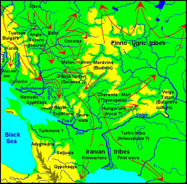
Herodotus wrote that the Callipidai were Hellenic Scythians. We have no sure prerequisites to identify them with any historical ethnic group. Maybe they spoke special dialect of Greek, badly understood by true Hellenes. In this case, the Callipidai may be the descendants of those Proto-Greeks which remained in the Ukraine after the bulk of them went to the Peloponnese. Summing up our discussion of the ethnic composition of Eastern Europe since the end of the 2nd and during the first half of the 1st millennium BC, we submit a map of migration of the population in this period of time (see map below).
Map 10. The directions of the migrations of ethnic groups in Eastern Europe in the end ІІ-го – the beginning І mill. BC.
Moving to the east and south-east, the Bulgar during the 1st mill BC gradually settled the steppe part of the left bank and there entered in a long and close contact with the Magyars, as evidenced by the numerous lexical correspondences of the Chuvash and Hungarian languages. Being here in a few centuries, the Bulgar have created a culture of a high level which is known as the Scythian. In the steppes of Ukraine and Northern Caucasus, they have established and maintained contact with the cultural centers of agricultural Asia Minor and the Balkans. Sharing with them the experience and technology, they created a culture on a local basis. Herodotus identified as the parts of the whole Scythian community four distinct groups – the Scythians-farmers, the Scythians-plowmen, the Nomadic Scythians, and the Royal Scythians. In historic times we know already two ethnic communities, which we relate to the Ancient Bulgar – the actually Bulgar and Khazar. The Khazars had semi-nomadic and semi-agricultural economy but the Bulgar were nomads (PLETNIOVA S.A., 1986: 8-21). It is difficult to judge how agricultural tribes under the influence of natural conditions may shift from farming to nomadic economy, so the identification of four Scythian tribes of Herodotus with later Bulgarish tribes is difficult.
Obviously, the four tribal groups of the Scythians were not united in a power state, because in the middle of the 3rd century BC, as testified Diodorus Siculus, caming from the Don Sarmatians devastated much part of Scythia and established their rule over it. Archaeological evidence in favor of the invasion of the Sarmatians which resulted in "at the beginning of the IV century BC "Royal Scythians ", described by Herodotus, lost their dominant position in Scythia" (SULIMIRSKIY T. 2008 – in Russian – Changes in the ancient Scythians).
Retreating before the rush of the Sarmatians, the Scythians had left vast areas of Azov coast, although a deal of them stayed on the banks of the Lower Dnieper, "where a half dozen settlements was arisen such Zolota Balka, Znamenka, Liubymivka and others moved to the Crimea, where they formed a Scythian Kingdom, or Scythia Minor with its capital in Naples”. Another part of the Scythians went beyond the Danube and settled in Dobruja, formed another Scythia Minor here. However, some scientists doubt that it is the Sarmatians have been responsible for the decline of "Great Scythia":
Final Great Scythia Sarmatians and resettlement on the northern Black Sea separates a century gap, which does not allow to connect these two events (POLIN S.V., SIMONENKO A.V. 2004: 372).
It is still difficult to talk about the ethnicity of the population of the Northern Black Sea region at the time when the Goths came here. It is possible that they didn’t caught the Scythians, but found their traces in place names. Iordanes, in his "Getica" rather scanty described the coming of the Goths for new place of settlement, but it does have such evidence:
But when the volume of the people increased greatly and Filimer, son of Gadaric, reigned as king -about the fifth since Berig – he decided that the army of the Goths with their families should move from that region. In search of suitable homes and pleasant places they came to the land of Scythia, called Oium in that tongue (JORDANES. 1960: 25).
>
Namely by which language was named the land, it is not clear from the context – Scythian or Gothic. Jordanes commentators believe that Oium is a Germanic word (supposedly Gothic *ajum akin to Ger Aue "valley, meadow" existed in the Gothic language). If we turn to the Chuvash language, we find the word uçam "area, place", which has matches in other Turkic languages (Turkm., Kirghiz., Yakut. orun, Tat. uryn, Kaz. oryn, etc.) Complex transformation Turkic r - j – çcorresponds to the phonological patterns of the Chuvash language (cf. Chuv ura "a foot" – Turk. ajak "a foot", Chuv çĕr "hundred" – Turk juz "hundred"). The Goths just could borrow the Bulgar for the name of this land. But even if it has Germanic origin, it does not change anything, because the very existence of this word in the Chuvash language speaks of Gothic-Bulgarish language contact in the 2nd cent AD in the Northern Black Sea coast. Jordan was also confirmed this:
Farther away and above the Black Sea are the abodes of the Bulgar, well known from the wrongs done to them by reason of our sins (Ibid: 37).
Judging from the context, the area Oium was on the Left Bank of the Dnieper. In later sources, the Goths, as well as Bulgarians, often referred as the Scythians by the name of the country they inhabited:
Das Reich der Skythen, die einst Herodot beschrieben hat, war länger aus den Steppen am Nordufer des Schwarzen Meers verschwunden. Dennoch betrachteten die Bizantiener noch ein Jahrtausend nach dem Klassiker der Geographie die Bewohner der Länder jenseits des „Pontos Euxines“ als Skyten (POHL WALTER. 2002: 22)(Translation: Scythian Empire, which was once described by Herodotus, has long vanished from the steppes of northern Black Sea coast. However, the Byzantines for a thousand years after the classic geography called residents on the other side of „Pontos Euxines“ Scythians).