


The Development of Siberia and Far East by the Anglo-Saxons
While searching for ancient Anglo-Saxon place names in Continental Europe, it was found that a large their part is located in Eastern Europe and one clusters of them falls on the territory of the former Rostov-Suzdal principality and in the immediate vicinity (see the Google map below). This and other facts gave grounds to assume that in the middle of the 1st millennium AD Anglo-Saxons laid the foundations of Russian statehood. However, there was no mention in the annals about presence in the principality of the people which differed greatly in language from the rest of the population. Of course, the Anglo-Saxons were not in much number, they were only the ruling elite of the tribal alliance known in history under the name of Muroma. However, it is difficult to imagine that they disappeared without a trace among the local Finno-Ugrians and later arriving Slavs. Without making specific assumptions, but only continuing the search for Anglo-Saxon toponymy, I noticed that some European place names have doublets in Siberia and the Far East. After expanding the search area beyond the Urals, it turned out that this is not an accident, but a certain regularity. Discovered new Anglo-Saxon place names stretched as a narrow strip from the Urals to Lake Baikal. The reasons that caused the Anglo-Saxons to leave their habitats can only be assumed, since the beginning of their movement beyond the Urals and further to the east is unknown.
The area of the Upper Volga, inhabited by Anglo-Saxons, was, in the words of S.M. Solovyov, the "state core" of Russia, but for the creation of the state, it was prepared in the best way economically, but not politically. After the entry of Rostov-Suzdal land into the state of the Kiev Rus', the local tribal elite could not resist the onslaught of the Kiev authorities. Thanks to the experience of state building, acquired in close contacts with Byzantium, the dynastic rule established in Kiev understood the importance of economic predominance for political domination. Applying diplomacy and military force, the Kiev proteges sought to use the capital accumulated in Rostov’s and Suzdal’s nobility during the heyday of trade with the countries of the Arab Caliphate. As a stronghold in the newfound land, the aliens laid the city of Vladimir on the Klyazma River, transforming it into a fortress from time to time. The policy of Andrei Bogolyubsky, who consolidated in the city after Kiev Prince Yuri Dolgoruky and needed funds for the construction of other cities, caused great dissatisfaction with the local boyars, and in particular, them from the Anglo-Saxon clan of the Kuchkovichs. Their struggle with the prince ended with his assassination in 1174. One can assume that after such an outcome, the Anlo-Saxeonswere deemed to migrate beyond the Urals for the better, fearing the revenge of the numerous relatives of the prince
Anglo-Saxon place names in Eastern Europe
Direction of searching was denoted by place names in Eastern Europe already recognized as Anglo-Saxon ones, such as Markovo (seven cases), Markova (two cases), Firsovo (three cases), Akhtyrka, Firstovo, Fofonovo, Churilovo (see The Complete List of Anglo-Saxon Place Names in Continental Europe). This strip of place names stretches along the border of the forest and steppe and, evidently, marks a convenient route for moving eastward. Of the others, one can most confidently speak of the following in the direction from west to east:
Verkhby and Nizhny Тагил on th Tagil River in Sverdlovsk Region – OE. tægel "tail".
Firsovo, villages in Rezhevski urban district of Sverdlovsk Region and in Pervomaysk district of Altai Krai – OE. fyrs "furze, gorse, bramble" (Genísta).
Chetkarino, a Village in Pyshma town district of Sverdlovsk Region – OE. ciete "cabin, closet", carr "rock".
Miass, a sity in Chelabinsk Region – OE meos "swamp".
Churilovo, a village in Krasnoarmeisk district of Chelabinsk Region – OE. ceorl "a man, peasant, husband", Eng. churl.
Markovo, villages in Uvel district of Chelabinsk Region, Ketovski district of Kurgan Region and Zavodoukovski district of Tyumen Region – mearc "border, end, district", "sign", mearca "determined space".
Shadrinsk, a town in Kurgan Region – OE. sceard "mutilated, chipped" with metathesis of consonants.
Bolshaya Riga, a village in Shumikhinsk district of Kurgan Region – OE. ryge "rye".
Vagina, a village in rural settlement Yurminskoye in Tyumen Region – OE. wagian "to move, shake".
Rezanova, a village in Vikulovski distrivt of Tyumen Region – OE. 1. rāsian "explore, investigate", 2. racian "rule, lead".
Firstovo, a village in Bolsheukovski district of Omsk Region – OE. fyrst "первый".
Ingaly, a village in Bolsherechenski district of Omsk Region – OE. Ing "name of god", āl "fire".
Atrachi, a village on the shore of the lake of the same name in the Tyukalinsky district of the Omsk region. – OE. ātor, ætrig "poison", cio "jackdaw".
Anglo-Saxon place names in Asia
It was were considerably more difficult for Anglo-Saxon pioneers than for Russian Cossacks who set out to conquer Siberia, therefore their advance in the direction of Lake Baikal could take several centuries. Even at the turn of the 17-18 centuries, "the whole journey from Moscow to the Amur lasted three seasons, or two winters and one summer, or two summers and one winter… and all this because of the lack of roads" (WITSEN NIKOLAES. 1705). During the long migration, the Anglo-Saxon population had to increase significantly. In each newly created town, migrants left a small garrison, which eventually will be dissolved later among the incoming Slavic population. The descendants of these people, now called the Chaldones, preserved the legends about their settlement in Siberia even before the appearance of Yermak Timofeyevich and his followers.
Russian conquest of Siberia in the 17th century passed surprisingly very quickly. After the campaign of Yermak in 1581-1585 it took only about ten years when the township of Tomsk was laid in almost two thousand kilometers from the Urals. Soon Tomsk became a Russian strategic and military center Siberia. Overcoming such a long distance off-road would be absolutely impossible without the use of waterways, in particular the Ob River. The Anglo-Saxons, judging by place names, moved by land, but the territory they mastered in the upper reaches of the Ob River laid the foundation for the development of Siberia and the Far East even before the arrival of the Russians. The area along the banks of the Ob River was favorable for life, in addition, the depths of the Salair Range were rich in various mineral deposits. The Anglo-Saxons founded here several settlements that still exist, preserving their original names, sometimes in a somewhat Slavized form. These include:
Verkh-Irmen, a village in the Ordynsky district of the Novosibirsk region – OE. iermen "graet, strong".
Shadrino, villages in Kalmanski and Tselinny districts of Altai Krai and Iskitim district of Novosibirsk Region – OE. sceard "mutilated, chipped" with metathesis of consonants.
Toguchin, a town in Novosibirsk Region – OE toga "leader", cynn "family, people".
Salair, a town in the urban district of the town of Guryevsk in Kemerovo Region – OE. sala "sale, selling", iere, ōra "ore". In the town there is a mining and processing plant extracting and producing gold, silver, zinc, lead.
Shanda, a village of Guriev district of Kemerovo Region – OE scand1. "shame", 2."crook, deceiver".
Barnaul, the administrative center of the Altai Krai – OE. byrne "breastplate", ūle "owl". Plumage of an owl resembles chain mail. Obviously, the city made armor like "owl".
Only a part of the Anglo-Saxons stayed on the upper reaches of the Ob River, the main bulk of them moved on, basing new settlements along the way:
Tuim, a village in the Shirinsky district of Khakassia – OE. twinn "double, twin".
Bolshaya Irba, an urban settlement in the Kuraginsky district of the Krasnoyarski Krai – OE. ierfa, Ger. Erbe "heritage".
Gagul', a village in Ermakovski district of the Krajanoyarski Krai – OE. gāgul "throat, maw".


")

Bryanka, a township in Severo-Yeniseysky gistrict of Krasnoyarsk Krai – OE. berian "bald, uncovered" and –gē "district, area".
Vangash, a township in Severo-Yeniseysky gistrict of Krasnoyarsk Krai – OE. wang "level, flat", asce "dust, ash".
Taking into account the last two toponyms, it can be assumed that the Anglo-Saxons did not go further eastward through the forest massifs, but descended on the Yenisei to the mouth of the Angara River, and then went upstream to Lake Baikal. Along the Angara Anglo-Saxons founded such settlements:
Badarma, a township in Ust'-Ilim district of Irkutsk Region – OE. bād "tribute", earm "poor, miserable".
Sedanovo, a township in Ust'-Ilim district of Irkutsk Region – OE. seddan "saturate".
Zima, a town in Irkutsk Region – OE. sīma "tape, chain, stripe".
Mandagay, site in the Cheremkhovo district of the Irkutsk region – OE. mann "man", deag "convenient, suitable".
Orlik, a village, the administrative center of Okinsky district of Buryatia – OE. orlege "fight, war".
The natural resources of Dauria provided good opportunities for the development of this region for the Anglo-Saxons arrived in the Trans-Baikal land. Here they founded many of their settlements, the inhabitants of which were united under the rule of the tribal elite. With this tribe we associate the Merkits, who played a great role in the fate of Genghis Khan (see the section Anglo-Saxons in Genghis Khan's Fate). Dauria became part of the Mongolian empire, but it evidently represented a fairly independent economic and military unit and remained so until the arrival of Russian pioneers in Siberia. In favor of this assumption says that a detachment of Cossacks under the command of Petr Beketov had been sent for reconnaissance not to Dauria from the town of Yeniseysk (built in 1616), but to the Lena River. They had an order to found a foothold on its banks. Moving downstream, the detachment reached the mouth of the Aldan River and Beketov laid Yakut hillfort in these places in 1632. To conquer the densely populated Dauria, Moscow could not yet provide sufficient forces. Among the possible settlements founded by the Anglo-Saxons in Dauria, the most convincing transcription of the names are as follows:
Jida, a village in the Dzhidinsky district of Buryatia – OE. giedd "singing, poem".
Fofonovo, a village in the Kabansky district of Buryatia – OE. fā "colorful, motley, potted, dyed", fana "cloth".
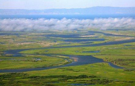
Selenga, a village on the bank of the river of the same name in Tarbagatay district of Buryatia – OE syle(n) "morass", -gē "district".
At left: The delta of the Selenga River
Ust'-Bryan', a village in Zaigraevsky district of Buryatia – OE. bryne "fire".
Kizhinga, a village, the administrative center of the Kizhinginsky district of Buryatia – OE. *cieging "calling" from ciegan "to call".
Dauria, the historical and geographical region within the modern Republic of Buryatia, the Trans-Baikal Krai and the Amur Region – OE. deor, Eng. deer.
Khilok, a town in the Trans-Baikal Krai – OE. *hillock from hill "hill", Eng. hillock.
Duldurga, a village in the Trans-Baikal Krai – OE. đylđ "suffer", wœrig "tiredness".
Chita, a city, the administrative center of the Trans-Baikal Krai – OE. ciete "cabin, closet".
The Daur people were engaged in farming, cattle breeding, they melted silver ore, traded with the Tungus and the Chinese. The Daurians bartered bread with the Tungus for sable furs and sold them to the Chinese, receiving silk fabrics and other goods in return (SHRENK L. 1883. 163). Knowing about the wealth of Dauria and wishing appropriate it for profit of Russia, the voyevoda (governor) of Yakutsk Petr Golovin sent a well-armed detachment under the command of Vasily Poyarkov to reconnaissance in this country in 1643. Arriving in Dauria, the scouts saw before them such a picture:
In the valley of Zeya River there were villages of the Daurians, fields and arable land. The houses were mostly strong, spacious, with windows covered with translucent oiled paper. Local residents wore silk and cotton fabrics of Chinese origin, received in exchange for furs. The Daurians were engaged in agriculture, had arable land and many livestock. They paid tribute to the Manchus (BALANDIN RUDOLF KONSTANTINOVICH). The site "100 great expeditions"

The Daurians met the uninvited guests hostilely and refused to pay the yasak (tribute) to the Russian Tsar. Perhaps the memory preserved legends of the conflict of interests between the Andlo-Saxons and the Rus in Rostov and Suzdal. Poyarkov's detachment was forced to leave Dauria. Descending down the Amur River, the unsuccessful scouts reached the Sea of Okhotsk and, moving along its shore, approached the mouth of the Ulya River, and along it went to the Lena basin. In Yakutsk they returned three years after the beginning of the expedition.
Travelers' stories about the richness of the grain-rich Dauria prompted Russians to send a new, more numerous and better-armed expedition under command of Yerofei Khabarov for conquest it. In 1649-1652 years he, acting "with fire and sword", ravaged Dauria and eventually forced the locals to leave their places and seek new happiness under the auspices of the Manchus. Khabarov, in spite of the rich gifts to the tsar, was, by his own order, beat by a whip for his "exploits", but nevertheless left in the service. The devastation of Dauria by the Cossacks has been described by many historians. In particular, L. Schrenk, having his opinion on these events, refers to J.G. Georgi and Ritter in these words:
Georgi repeatedly says that the Daurians, the ancient inhabitants of the region named after it, were engaged in mining here, until, as a result of the conquest of this region by the Russians, they voluntarily left it and moved to the Chinese empire, after which the mining and melting art in Dauria was obliterated. Ritter, obviously had the same opinion: he calls the Daurians as "a peaceful, cultural people knowledgeable in the mining art". At the first irruption of wild Cossack teams of Khabarov and his successors they retreated from their ore mountains almost without resistance, leaving behind a nearly desert, where, in the aftermath, the Russian mining industry caused a secondary colonization in some places(SHRENK L. 1883. 167-168).
The first Russian "researchers" of the Far East, like Poyarkov and Khabarov, didn't left more or less detailed information about the local population. True, here and there some references to "bearded daurs" have been preserved, what can speak in favor of their European appearance, since most of the local people of the Mongoloid type had no dense beards.
The study of the toponymy of the Amur Region allows us to state that some part of the Anglo-Saxons moved from Dauria downstream along the Amur River. They also named this river, if we take into account OE eam "uncle from the mother's side" and ūre "our". This definition of the Amur has survived to our time in the expression "Amur-father", which exists in the Far East. On the way they founded the following settlements:
Chaldonka, a township in Mogochinsky District of Zabaykalsky Krai and a mountain of Jewish Autonomous Oblast – OE ceald "cold".
Magdagachi, a township in Amur Regiom – OE. mæg "kinsman", deag "convenient, suitable", āc "oak".
Tynda, a town in the Amur Region. tind "top, point", tinde "tensioned".
Tygda, a village in the Magdagachi district of the Amur Region – OE. tigde "receiver, partner".
Shadrino, a village in Mikhylovski district of Amur Region – see above.
Gassi, a village and a lake in Nanaysk district of Kabarovsk Krai – OE. hæs "woodland", sæ "sea".
Lidoga, a village in Nanaysk district of Kabarovsk Krai – OE. lida "skipper, seafarer", oga "fear, scare".
Ukhta, a village in Ulchinski district of Kabarovsk Krai – OE. uht(a) "twilight, dusk".
Jaore, village on the west coast of the Amur estuary, near the confluence of the Jaore River in the estuary, on the cape with the same name, Nikolaevsky district, Khabarovsky krai – OE. ġear "defense", ġeare, ġearwe "good, sufficient, effective".
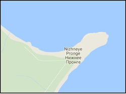
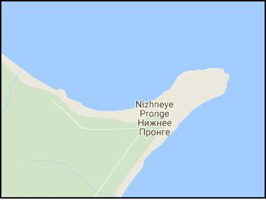
At right: Cape Pronge.
Nizhneye Pronge, a villge on the cape Pronge OE. preon "awl, needle", –gē "district, area". Cape Pronge juts out in the sea like needle (see the map on the right). In some places it can be read that the name has a match p'ro "small smelt" in the language of locals called Nivkh. But the motivation of such name for the cape and phonetic correspondence are questionable.
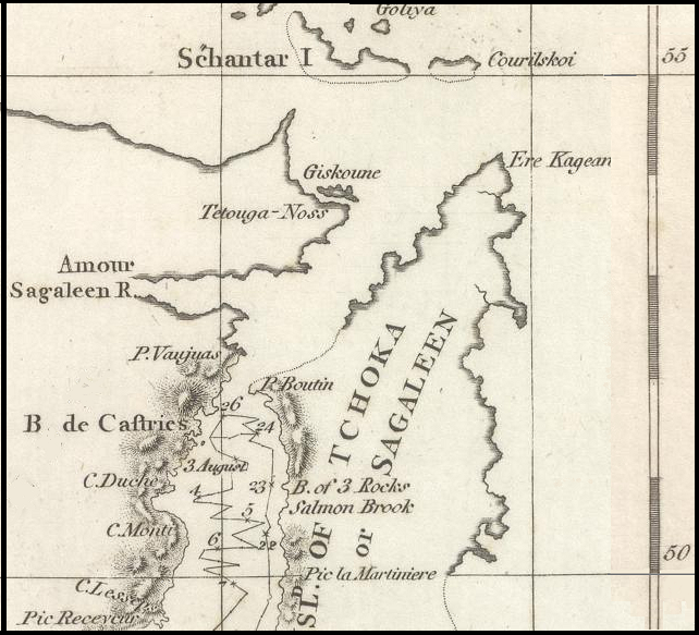
The English and French languages have the word prong "tooth, salience", so the name of the cape could have been given by English or French navigators or missionaries. However, the explorer of the Tatar Strait La Perouse reached only the De Castri Bay, located 175 km south of Cape Pronge. On the map of the sailing of La Perouse (see below), neither Cape Pronge nor Cape Jaore are marked, which implies that these names were given not by him. Investigating in 1797 the Tatar Strait William Broughton confirmed the erroneous opinion of La Perouse that Sakhalin is a peninsula.

At left: A part of The chart of Lapérouse's discoveries in the Sea of Japan and Sea of Okhotsk Photo from Wikipedia.
Except La Perouse and Broughton nobody sailed here before Nevelskoy, who in 1849 discovered the strait named after him. Krusenstern, trying to enter the Tatar Strait from the north, did not reach the mouth of the Amur River. As for the missionaries in Primorye and Sakhalin, in particular, their so-called Manchu expedition in 1709-1710 is known.
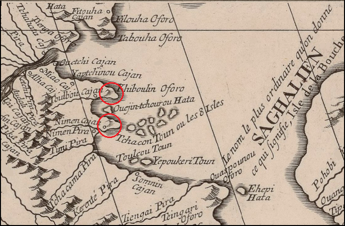
Obviously, according to their data, a map was compiled and included in the atlas of the French cartographer d'Anville (D'ANVILLE JEAN, 1737, 80). On this map there are many names of rivers and settlements, but Pronge and Jaora are absent, although several others have survived in almost the same form: Tabouha (Tebakh), Pohobi (Pogibi), Pilantou (Piltun), Laha (Lach), etc.
At right: The mouth of the Amur River. Fragment of d'Anville's map.
On the map, the alleged places of the capes Pronge and Jaore are marked in red. Their names given at that time are completely different. Thus, the names Pronge and Jaore arose later, but their Nivkh origin is doubtful. Probably, the Anglo-Saxons came to Primorye after the missionaries and named several geographical objects by their kanguage. During his voyage Nevelskoy firstly heard the names of Pronge and Jaore from the locals. It is highly doubtful that the Nivkh could spell them, but Nevelskoy does not say exactly from whom he heard these names. It is a enigmatical.
On Sakhalin there are also several place names can be deciphered using the Old English language:.
Trambaus, a village in Aleksandrovsk-Sakhalin district – OE. đrymm "amount", beaw (pl. beaws) "gadfly".
Tangi, a village in Aleksandrovsk-Sakhalin district – OE. tang(e) "tongs, pliers".
Mangiday, a village in urban Aleksandrovsk-Sakhalin district – OE. mangian "trade", dæġ "day".
Nogliki, a township – OE. nō "no, not", glīg "plesure, joy".
Tungor, a villag in Okha urban district – OE. đung "aconitum" (a plant), ōra "bank, edge".
Thus, we have some evidences that the Anglo-Saxons reached the Sea of Okhotsk along the Amur River. The total number of Anglo-Saxon place names in Primorye and Sakhalin is quite large, and therefore the Anglo-Saxons should have been a significant part of the local population here. Being the people of a higher culture than the Nivkh, the Anglo-Saxons could not dissolve among them without a trace. Nevelskoy and his people had to meet them. Why did not you have any information about this meeting? The solution lies in the fact that Russia could not let spread of information about some Europeans settled the Far East before the Russians. The discovery of Nevelskoy provided Russia with the opportunity of a convenient access to the Pacific Ocean along the Amur River. The significance of such access was recognized by the tsarist government since the time of Catherine II, therefore, as soon as such an opportunity arose, Russia immediately activated diplomatic efforts with the intention of obtaining China's consent to join the Amur land. These efforts had success in the conclusions of the Aygun (1858) and Peking (1860) treaties in favor of Russia. But even earlier, the Crimean War (1853-1856) began, during which Englishmen and Frenchmen attempted to gain a foothold on the northwestern shores of the Pacific Ocean. The Anglo-French squadron approached Petropavlovsk-Kamchatsky, but could not seize it. Nevertheless, fearing a new attack, the Russian command decided to evacuate the garrison at the mouth of the Amur River.
It can be assumed that recognition by Russia the presence among the aboriginal people of the Primorye a tribe, speaking an unknown dialect of English, could give reason for United Kingdom claim to master this country under the pretext of protecting its compatriots. In such circumstances, the tsarist government considered it best to hide all information about this mysterious tribe from the world community. In his memoirs Nevelskoy kept silent about contacts with the local population to the south of the mouth of the Amur River, and the circumstances of the voyage along the capes of Pronge and Jaore to the strait named after him described very scanty (NEVELSKOY GENNADIY IVANOVICH, 1878). All the documentation received from Nevelskoy could be classified as secret, but it would be impossible to hide the existence of an entire Anglo-Saxon tribe. It remains to be assumed that the unfortunate Anglo-Saxons should once again flee from the Russians. There was no other way to Manchuria either. Their tracks have to be found there.
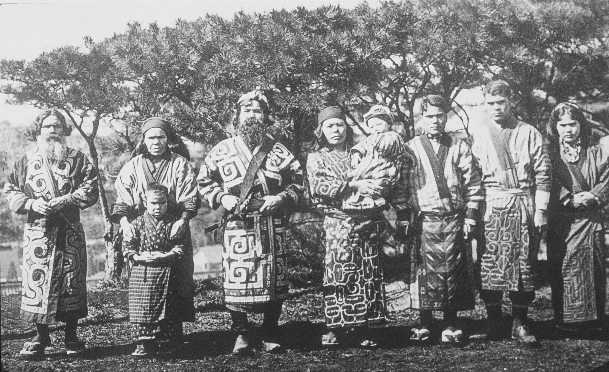
However, there is another possibility of explaining the complete disappearance of the Anglo-Saxons in the Far East. They could be assimilated among the Ainu by going to their language. The Ainus have signs of a European race and they could have been introduced by Anglo-Saxons (see photo below).
Ainu group.1904.


