|
Turks as Carriers of the Corded Ware Culture in Central-Eastern Europe.
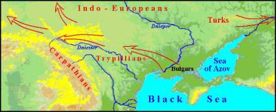
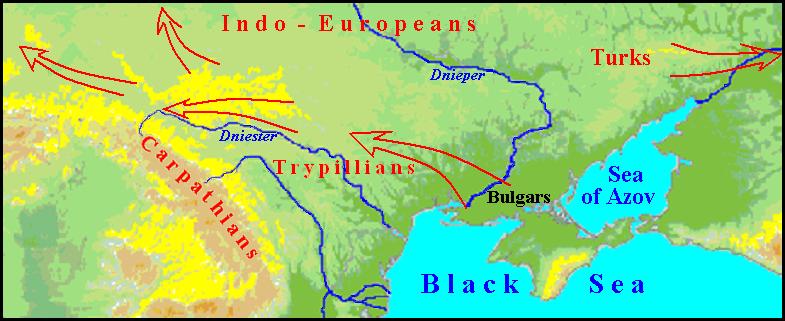
Evidence of the presence of the Turkic tribe Bulgars in Western Ukraine are separated in the special section Discussion, there will be placed materials about further their expansion and probably other Turkic tribes in different directions as carriers of the Corded Ware culture.
Archaeological data evidence that at the beginning of III mill. BC similar culture appear in Central Europe having such characteristic features as Corded Ware and battle-axes. At least, their appearance in Małopolska (Cracow and Sandomierz and other groups) can be dated by Radiocarbon method since 2900/2800 years. BC [WŁODARCZAK PIOTR, 2001: 106].
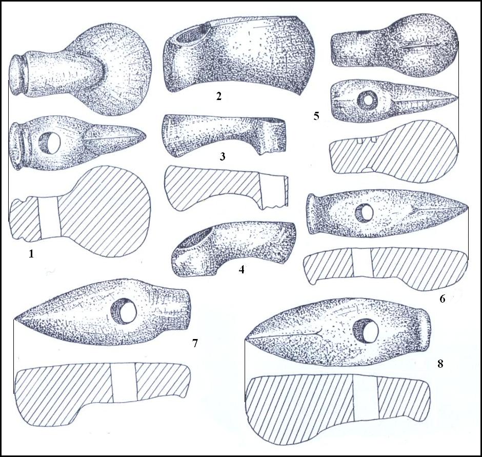
Left: Battle-axes as one main feature of Corded Ware culture.
Stone and copper axes found accidentally in Fore-Carpathia and Podolia.
1. – Rakovchyk, 2. – Pistyn, 3. – Komariv, 4. – Dereviane, 5. – Bedrykivrsi,
6. – Bohorodchany, 7. – Halych, 8. – Dashava (SVESHNIKOV I.K. 1974, Fig. 18)
The complex of the Corded Ware culture, some of which have such names as Beaker culture, Single Grave culture, Battle-axe culture etc was spread on the space from the Dniester River to the Rhine, from southern Sweden to the foothills of the Alps. Turks as carriers of traditions of Corded Ware and Battle-Axe settled quickly upon large territory through the use of riding horses and primitive carts. Their spreading was indebted also due climatic changes in the arid Subboreal period when the zone of steppes advanceв on the north and west and tribes of nomadic cattle-breeders moved with it. The extent of this movement is illustrated by the fact that there are only in Saxony and Thuringia 1300 sites of Corded Ware Culture.(HERMAMM JOACHIM. 1982: 61)
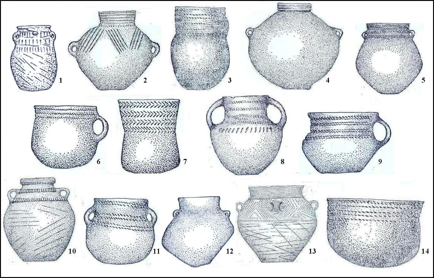
Right: Some types of Corded pottery from Ukrainian sites.
1, 10, 13 – Strzyżów group; 2, 3, 4, 7, 14. – Upper Dnister group;
5, 6, 8, 9, 11, 12. – Zdovbytsia group. (SVESHNIKOV I.K. 1974, Fig. 4, 5, 6, 9, 26, 38, 39, 48)
Settling quickly over a large area, Turks influenced the culture of the local population, giving rise to new cultural traditions. Inverse influences were very minor. For example, the aliens have borrowed from Trypillians symbol "Tree of Life". However Turks brought with themselves the image of the Bull and the Phallic saints as a symbol of male power and, as a consequence, patriarchal clan system, as well as ancestor worship and funeral rite. (ALEKSEYEVA I.L. 1991: 20-21)
Most clearly these effects can be observed in the archaeology of the Right-bank Ukraine. The newcomers bring their own items into Trypillian culture existed here at that time. For example, Usatovo group sites associating with the cultures of the Balkan- Danubian tradition, "but one of the most important and characteristic features that make this group highlight – obsequies – is certainly associated with "Old Pit tradition" [MASSON V.M., MERPERT N.Ya. 1982:329]. In addition, Trypillian clay-ware with sand and pounded shells, a feature that distinguishes Pit culture, occurs on the banks of the Southern Bug ans Ingulets Rivers [ibid., 211]. Human skeleton buried in the back with knees bent, ie in a pose typical of carriers so-called "Kurgan" cultures, which was found near the village of Nezvisko of Ivano-Frankivsk region, may indicate further advancing Turks westward. At the same time, the anthropological study of archaeological sites of the North-Western Black Sea Region suggests about the process of cross-breeding and mutual assimilation of Trepillian population and arrived here tribes of Pit culture [ALEKSEYEVA I.L. 1978: 56].
Local cultures of Corded Ware complex are largely different from each other, but have many common features, the most important of which are:
1. spread in the forest and forest-steppe zone;
2. primary pastoral character;
3. temporary settlements with small hut dwelling type;
4. mainly burial mounds;
5. vessels of bowls and cups type with a rough (often spherical) down, decorated by cord and trees decorated ornament;
6. flint rectangular cross-sectional axes and stone axes of various types;
7. a significant amount of armaments;
8. patriarchal clan system;
9. traces of the cult of the sun and the earth;
10. Common (proto-European) anthropological features (SVESHNIKOV S.K. 1974: 170).
When Pit (Yama) tribes of early Bronze began settling in the area between the Southern Bug and Ingulets rivers, Trypillian culture was already at the stage of decline. When Pit culture tribes of early Bronze Age settled in the region between the Southern Bug and Ingulets Rivers, the local population was almost absent [SHAPOSHNIKOVA O.G. a.o. 1986: 59]. Trypillian culture developed mainly based on agriculture, which lost its efficacy without the use of fertilizers and crop rotation. At that time, nomadic livestock gave grater surplus product, as it could make better use of steppe resources. As a result, mutual assimilation of Trypillians anf Pit people was accompanied with the transition nomadic cattle-breeding. However, reverse transition to agriculture became inevitable with increasing population and start using more advanced methods of cultivation. About five centuries the population in the basin of the Middle and Upper Dniester River has led a sedentary life. Archaeological sites of Komariv culture, spread from the Southern Bug to Volyn, testify that economy of the bearers of this culture was based on sedentary farming and livestock-breeding.
While considering the topic of Turkic expansion into Central Europe the map of Bulgarish place names in system Google Map will be used as illustrative material (See below). Ease of use of this map is that it can be easily modify, the need for what will inevitably occur in the course of further study.
Icons on the map mark hydronyms by blue, oronyms by deep red. Names of settlements are marked by different colors. The purple mark those that can be attributed to Corded Ware time or close to it. Pink – later or indefinitely. Pale purple in eastern Ukraine marked place names that may relate to the historical time. Individually are singed place names that contain options of a root shep/ship, they are spread in different countries and are marked in light-blue. Doubtful cases – by yellow. Blue asterisks mark known sites of Corded Ware culture (hereinafter CWC) or groups of them, of yellow ones – sites of Trypilla culture next to settlements of Turks.
The accuracy of the picture being drawn about further expansion Turks as carriers of CWC in Central and Northern Europe depends on convincing interpretation of European place names by means of the Chuvash language. As always, the coincidence of names with the Chuvash words may occur, so the credibility of the interpretation of the local place names using the Chuvash language can be higher when the name is associated with the local conditions and also consist of logically related words.
For example, two villages with strange names for the Poles Shury and the Shurypily are located among the Masurian marshes. If we take into account Chuv shuras "swamp", the search for decrypt the second word is going to be successful. If Chuv. pile buzz" (about mosquitoes) add to Chuv. shura, it can be understood as "mosquito swamp". Buzzing mosquito Clouds over the marsh gavea good reason for such name. This conjecture is confirmed by a similar interpretation of the ancient name of Tallinn Kolivan using Chuv. kӳlĕ "lake" and văn, imitating the hum of insects. Lake Ülemiste is very close to Tallinn, and it is an additional argument in favor of this interpretation. There is the hill Toomemägi in the city of Tartu in Estonia which can be explained by Chuv. tără "summit" and tu "a mountain". The name of the German city of Nuremberg is well explained by Chuv. nür "humid, wet" and en "side", and this explanation is confirmed by preserved alluvial sediments of floods of Pegnitz River in the northern and north-eastern part of the city. There is in area Sösdala in Sweden CWC site and this fact confirms the explanation of this name by means of Chuv süs "hemp fiber" and tăla "homespun cloth".
It is acceptable that cattlemen used names ut "horse" and ĕna "cow" separately for naming ancient city of Lithuania Utena, but joining them in one word is incomprehensible. Naming by pastoralists some particular area as "watering place" for is conventional. This is what we have in the case of the Estonian town called Tapa (Chuv. tapă "watering place"). Explanation of names when they are concentrated in one place can also be one of the arguments but single toponyms decrypted using any language, of course, can not be conclusive.
These facts are enough an unprejudiced reader to agree that the ancestors of modern Chuvash settled half of Europe, besides, who does not want to believe no amount of evidence will not help.
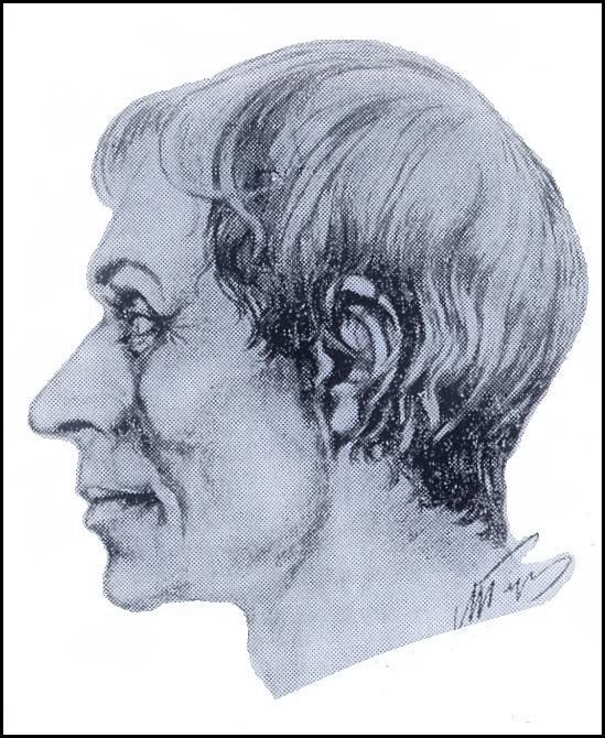
Study of skulls from burials of CWC gives grounds to say that the carriers om them were naturally people of Caucasoid type
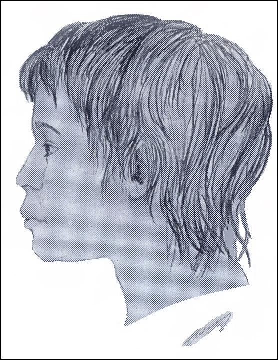
Left: The portrait of a buried boy 14-14 years old on the settlement Zoziv I. Reconstruction after the skull wass made by G.V. Lebedynski (SVESHNIKOV I.K. 1974, Fig. 33).
Right: The portrait of a buried man 20-22 years old in the village of Pochapy of Lviv Region Reconstruction after the skull was made by Gerasimov M.M.(SVESHNIKOV I.K. 1974, Fig. 21)
Nomadic Turks had no permanent place of residence, their stationary settlement appeared after changing economy to mixed form of cattle breeding and crop farming. Corded Ware culture, certainly was left by nomads, so the names of settlements attributed to the Bulgar correspond to later time when the Turks have settled down. Although the space of their settlements in general could remain the same.
Analyzing the map and knowing that the Turks originally inhabited the steppe zone, you can trace the direction of their migration, taking into account the spread of the CWC sites. Immediately it should be said that the two groups of place names shown on the map should be classified as referring to the For-Scythian and Scythian period. The first group is place names in Hungary, where monuments CWC were not found, and the second group is place names of Central and Western part of Ukraine, which are corresponded with Chornolis culture.
The Movement of Turks northward which can be marked by the area of Middle Dnieper culture has not left clear traces in place names. Perhaps they were erased by time. Middle Dnieper culture was located mainly in the area lined by the rivers Dnieper, Teteriv, and Ros', a part of space of Trypilla culture before. Sites of CWC on the habitat of the Indo-Europeans except Vollynia are absent. The reasons for this may be different. Perhaps more warlike Indo-Europeans did not allow to settle strangers in their countries, but most likely there was no free place for settlement. So the excess population of Middle Dnieper culture passed through the land of Indo-Europeans, obviously along the Desna River in the Volga basin where Turks created Fatyanovo culture as a variant of CWC. Another part of the Turks, the creators of a similar variant, Balanovo culture culture, obviously moved from the Low Don along the Volga. Ethnicity of place names the Volga region was not considered because their stratigraphy is impossible, for the a permanent presence of the Turks in the Middle Volga catchment which we correspond with the Volga Tatars.
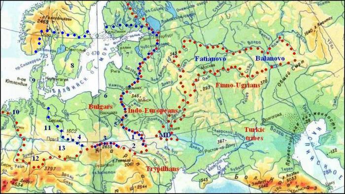
Two space belonging to Corded Ware culture are marked on the map by red spots; a united area of the Middle Dnieper culture (MD on the map), Fatyanovo and Balanovo variants of CWC among Finno-Ugric settlements and common area of different variants of CWC in Central Europe marked by ciphers: 1 – Horodok-Zdovbytsia group, 2 – Fore-Carpathian group, 3 – Krakow-Sandomierz group, 4 – Silesian group, 5 – Strzyżów group, 6 – Vistula-Neman (Rzuców) group, 7 – Estonian group. 8 – Boat-Axe culture, 9 – Single Grave culture, 10 – Netherlandish group, 11 – Central-German group, 12 – Alpine Stilt house culture, 13 – Bohemian-Moravian group. Blue spots mark birder of spread of place name explained by means of Chuvash which could be connected with CWC.
The Movement of Turks northward which can be marked by the area of Middle Dnieper culture has not left clear traces in place names. Perhaps they were erased by time. Middle Dnieper culture was located mainly in the area lined by the rivers Dnieper, Teteriv, and Ros', a part of space of Trypilla culture before. On the whole sites of CWC on the habitat of the Indo-Europeans except Vollynia are absent. The reasons for this may be different. Perhaps more warlike Indo-Europeans did not allow to settle strangers in their countries, but most likely there was no free place for settlement. So the excess population of Middle Dnieper culture passed through the land of Indo-Europeans, obviously along the Desna River in the Volga basin where Turks created Fatyanovo culture as a variant of CWC. Another part of the Turks, the creators of a similar variant, Balanovo culture culture, obviously moved from the Low Don along the Volga. Ethnicity of place names the Volga region was not considered because their stratigraphy is impossible, for the a permanent presence of the Turks in the Middle Volga catchment which we correspond with the Volga Tatars.
The most concentration of Turkic place names (actually Bulgaris) is found in western Ukraine. If you don't take into account settlements at Chornolis culture time, the eastern boundary of the cluster runs along the Zbruch River. The CWC sites to the east of it also are absent. In principle, the nomadic Turks had to populate the region Podilla very scant on forests but they moved further westward into the forest zone of the Upper Dniester which begins beyond the Hnyla Lypa River. Obviously, the same reason was here as in the movement northward – the area was quite densely populated by farmers of Tripoli culture. Trypilla sites shown on the map evidence about high density of the Population on Podilla. It was impossible for nomads to find here enough free asture place for their cattle herds. Beyond the Zbruch River on the left bank of the Dniester population density of Tripillians decreases gradually and Turks began to settle here. Trypillian settlements interspersed with Turkic ones, become rare though they drawn of thick band along the right bank of the Dniester to the mouth of the Hnyla Lypa River, and then disappear almost completely. Judging by the numerous toponymy, the majority of Turks (particularly the Bulgars) stayed in these places for a long time, but gradually settled into neighboring lands. Another part of two separate groups moved westward along the Carpathians and north bypass settlements Indo-Europeans. Separated from the main body, some of the migrants crossing Carpathians, settled in Eastern Slovakia, as evidenced by the collection of CWC sites in the valleys of the Ondava and Torysa (see the map below)
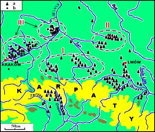
Left: The concentration of the finds of CWC in South-eastern Poland, Western Ukraine, and Eastern Slovakia (After J Machnik with modification). a – kurgan clusters and single kurgans, b – clusters and single flat graves. J Machnik marked by Roman numerals the subsequent developmental stages of CWC in Poland. The map from the publication on Academia.edu of Piotr Włodarczak and colored by the author.
Bulgars remained in Western Ukraine until Scythian times, when a new wave of their expansion across the Carpathians, on the Left Bank Ukraine and the Black Sea steppes started, as it still goes ahead. In these places, they became creators of cultures Komariv (15-12 cen. BC ) and Vysotska (11-7 cen. BC) and apparently took part in the creation of later cultures, it is difficult to say which without purposeful analysis of archaeological remains of the second half of the 1st cen. BC. But there is no doubt that some of the Bulgarian population remained in their places before the arrival of the Slavs, as evidenced by similar motifs in folk cultures of Chuvash and Ukrainians. Obviously, reliable material traces of their presence can be found too, such as, for example, in runic characters cave temple on the Dniester. Their similarity known Turkic ostalyayut not doubt that they left the Bulgars.
Turkic ethnicity of the creators of CWC caused readers great doubt. This is especially true for readers of Western Europe. For more convincing, a separate map of CWC sites and Bulgarish place names was compiled separately for Germany
Right: The map of CWC sites and Bulgarish place names in Germany
There are on the map red fire figures showing the locations of CWC sites in Germany,
yellow houses mark place names can be decrypted by means of the Chuvash language.
>
Aisch, Neustadt an der Aisch, a small town in the northern part of Bavaria – Chuv uj "field", jysch "family, owner, farm" (in other Turkic jiš "forest").
Ascha, a municipality in the district of Straubing-Bogen in Bavaria – Chuv ăšă "warm".
Aspach, a community in the Rems-Murr-Kreis in Germany (Baden-Württemberg) – Chuv. aš "meat" (in other Turkic "food"), păkh "to entertain, treat to".
Baar, a municipality in Aichach-Friedberg district, in Bavaria – Chuv. păhăr "copper"
Basel, a city in Switzerland – Chuv păsăl "to spoil, deteriorate"
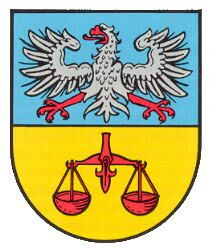
Böhl-Iggelheim, a municipality in the Rhein-Pfalz-Kreis, in Rhineland-Palatinate -Chuv ikkĕle "to double", ikkĕllĕ "duality". The historical coat of arms of Iggelheim with the balance can symbolize the duality of the court (see left).
Borna, a town in the Free State of Saxony
– Chuv parne "present, gift".
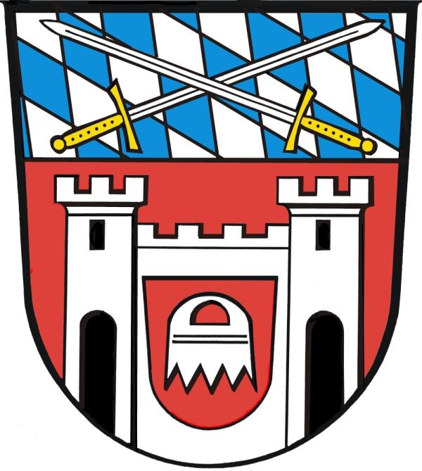
Cham, the capital of the district of Cham in the Upper Palatinate in Bavaria – Chuv khum "wave". The arms of the city since the Middle Ages has comb having a certain similarity with the wavy surface (see. The right). The city lies in the valley crossed by mountain range of Upper Palatine Forest having wave form. It is assumed that the name of the city has Celtic origin and means "curvature, waviness" (Wikipedia). The Turks settled Central Europe even before the Celts therefore the Celtic word could be borrowed from some Turkic dialect. See also Hamburg.
Cottbus, a city in Brandenburg, – Chuv kat "dike, dam" and păs "to break, disturb".
Gera, a city in Thuringia, – Chuv kĕrĕ "strong, solid, massive".
Hamburg, the Free and Hanseatic City – Chuv khum "wave". See also Cham.
Hanower, the capital of the federal state of Lower Saxony – Chuv khăna "guest", vere "custom, usage".
Hartha, a town in the district of Mittelsachsen, in the Free State of Saxony – Chuv khărta – 1. "patch, clout", 2. "rough country".
Homburg am Main, integral part of the community Triefenstein in Main-Spessart district (Bavaria) – Chuv. khum "wave". Coat of arms of the community (see. Right) is divided transverse by wavy line, which seems to symbolize the Main River flowing through Triefenstein. Then we would recognize a random match of a detail on the emblem with the meaning of the Chuvash word. However, there are still several settlements having the same name (in Saar et al.), as well as several places named Homberg. Among them there are those which have specific motivation for their names in place features. See. Also Cham, Hamburg.
Jena, a University city in Thuringia – Chuv yĕnĕ "den, lair, couch".
Jüterbog, a historic town in the Teltow-Fläming district of Brandenburg – Chuv yüte "to be exhausted", păk "to sleep, die"

Kandel, a town in the district of Germersheim, in Rhineland-Palatinate and a mountain of the Black Forest – Chuv kăn "potash", tĕl "place, country". Potash was recieved from wood in the Black Forest long since.
Kiel, the capital of northern German state of Schleswig-Holstein – Chuv kil "house, family, yard". The coat of arms of the city of Kiel is the so-called Holstein nettle leaf. The brick-built boat symbolizes city rights by the association with city-courtyard wall (see left).
Kirkel, a municipality in the Saarpfalz district, in Saarland – Tschuv khyr "pine-tree", kĕl "ach".

Kyritz, a town in the Ostprignitz-Ruppin district, in Brandenburg – Chuv kĕr "Herbst", eç "Arbeit". There is in the center of the city Coat of arms a golden sheaf symbolizing the finish of field work (see. right).
Nohra, a municipality in the Weimarer Land district of Thuringia, – Chuv nakhra "horn".
Nürnberg (at first Nuremberg), a city in the state of Bavaria – Chuv nür "moist, humid", en "site, land".
Pankow, the highest populated and the third borough of Berlin – Chuv pankav "silly"
Parchim, a town in Mecklenburg-Vorpommern – Chuv par "to give", khĕm "fire, flame".
Perkam, a municipality in the district of Straubing-Bogen in Bavaria – Chuv pĕr "lonely, single, whole, allein, alike", kăm "ash".
Salem, a municipality in the Bodensee district of Baden-Württemberg – Chuv selĕm "good, nice, beautiful"
Tarthun, a village and a former municipality in the district Salzlandkreis, in Saxony-Anhalt – Chuv tărtan "to swell", turtăn "to stretch out, lengthen", turtăm "load"
Teklenburg, a town in the district of Steinfurt, in North Rhine-Westphalia – Chuv tĕkle "still, quiet".
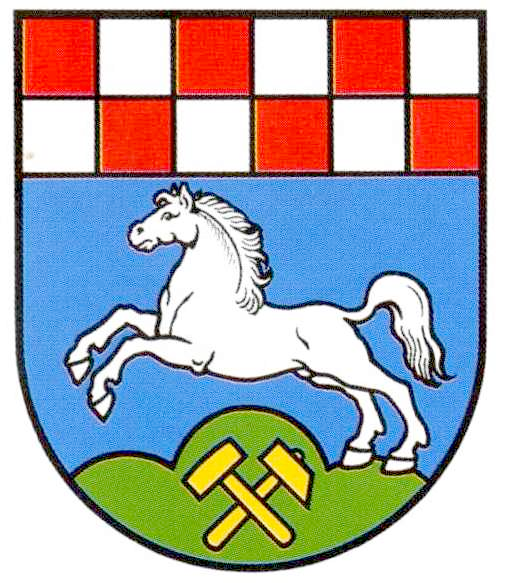
Zorge, a municipality in the district of Osterode, in Lower Saxony, Germany – com Turk. jorğa/jurğa "troat, amble" (Chuv çărkha). The municipality has the coat of arms with jumping horse (see left). The meaning of the name remained in human memory during long centuries.
So, we have a few matches between place names of Bulgarish origin and heraldry. Some of them may be random, but in other cases the name is explained by motivation of terrain features or probability of correspondences seems unlikely (as in the case of s name Zorge). There are two possible explanations for this phenomenon: 1. The population of Turkish origin coexist with the new settlers (the Celts and later the Germans) for several millennia and was assimilated already at historical time. 2. Interpretation of the names given by Turks remained in the memory of the local population regardless of its language during the same time.
| |